
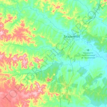
Tranqueras topographic map
Interactive map
Click on the map to display elevation.
About this map
Name: Tranqueras topographic map, elevation, terrain.
Location: Tranqueras, Tacuarembó, Uruguay (-31.79958 -56.24365 -31.72127 -55.88128)
Average elevation: 561 ft
Minimum elevation: 394 ft
Maximum elevation: 991 ft
Other topographic maps
Click on a map to view its topography, its elevation and its terrain.
Balneario Iporá
Balneario Iporá, Tacuarembó, 45000, Uruguay
Average elevation: 551 ft
San Gregorio de Polanco
Uruguay > Tacuarembó > San Gregorio de Polanco
San Gregorio de Polanco, Tacuarembó, 45200, Uruguay
Average elevation: 272 ft
Chamberlain
Uruguay > Tacuarembó > Chamberlain
Chamberlain, Tacuarembó, 45100, Uruguay
Average elevation: 397 ft
Rincón del Bonete
Uruguay > Tacuarembó > Rincón del Bonete
Rincón del Bonete, Tacuarembó, 45100, Uruguay
Average elevation: 243 ft
Paso de los Toros
Paso de los Toros, Tacuarembó, 45100, Uruguay
Average elevation: 220 ft
Piedra Sola
Uruguay > Tacuarembó > Piedra Sola
Piedra Sola, Tacuarembó, 45003, Uruguay
Average elevation: 768 ft