
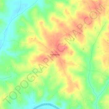
Harrisburg topographic map
Click on the map to display elevation.
About this map
Name: Harrisburg topographic map, elevation, terrain.
Location: Harrisburg, Charlotte County, Virginia, United States (37.00653 -78.76778 37.04653 -78.72778)
Average elevation: 453 ft
Minimum elevation: 338 ft
Maximum elevation: 564 ft
Charlotte County trails, hiking, mountain biking, running and outdoor activities
Other topographic maps
Click on a map to view its topography, its elevation and its terrain.