Geolocate

Quepos topographic map

Click on the map to display elevation.

Quepos

Quepos has an area of 235.81 km² and an elevation of 5 metres.

Wikipedia (CC-BY-SA 3.0)

About this map

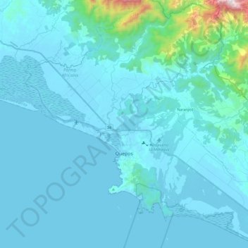
Name: Quepos topographic map, elevation, terrain.

Location: Quepos, Cantón Quepos, Puntarenas Province, 60601, Costa Rica (9.34452 -84.25419 9.57201 -84.02449)

Average elevation: 315 ft

Minimum elevation: -3 ft

Maximum elevation: 4,459 ft

Other topographic maps

Click on a map to view its topography, its elevation and its terrain.

Tierras Morenas

Costa Rica > Cantón Quepos > Savegre

Average elevation: 1,004 ft

Espadilla

Costa Rica > Cantón Quepos > Quepos > Espadilla

Average elevation: 128 ft

Gear up for your next adventure:

🌲Outdoor Survival Books - Best books on survival skills
🎁Geography Themed Gifts - Unique gift ideas for map lovers and geography enthusiasts
🧭Compass with Lanyard - Easy‑carry compass for navigation
🩹Survival Bandages - High‑quality bandages for emergencies
🧴Hand Sanitizer - Keep hands clean while hiking

As an Amazon Associate, this site earns from qualifying purchases at no extra cost to you.