Geolocate

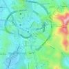
Rahjan topographic map

Click on the map to display elevation.

About this map

Name: Rahjan topographic map, elevation, terrain.

Location: Rahjan, Makkah Al Mukarramah, Makkah Region, Saudi Arabia (21.29667 40.03000 21.33667 40.07000)

Average elevation: 1,319 ft

Minimum elevation: 1,145 ft

Maximum elevation: 2,149 ft

Other topographic maps

Click on a map to view its topography, its elevation and its terrain.

At Tanim

Saudi Arabia > Makkah Region > Makkah Al Mukarramah

Average elevation: 1,115 ft

Ajyad

Saudi Arabia > Makkah Region > Makkah Al Mukarramah

Average elevation: 1,194 ft

Gear up for your next adventure:

🔭Telescopic Hiking Pole - Adjustable pole for hiking stability
🕶️Glacier Sunglasses - Side shields to protect eyes from high-altitude snow glare
📌Outdoor GPS Map App - Apps and devices for digital topographic navigation
📚Navigation Handbooks - Master the art of reading topographic maps and using a compass
🏔️Mountain Trail Maps - High‑detail maps for popular peaks

As an Amazon Associate, this site earns from qualifying purchases at no extra cost to you.