Geolocate

Gyangkar town topographic map

Click on the map to display elevation.

About this map
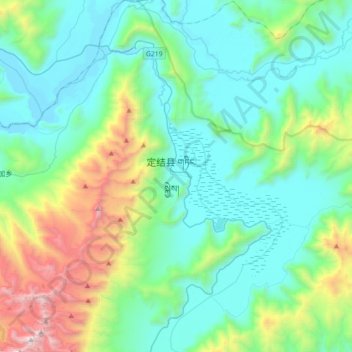
Name: Gyangkar town topographic map, elevation, terrain.

Location: Gyangkar town, Dinggyê County, Shigatse Prefecture, Xizang, China (28.21037 87.67064 28.52173 87.99351)

Average elevation: 15,223 ft

Minimum elevation: 13,599 ft

Maximum elevation: 21,220 ft

Other topographic maps

Click on a map to view its topography, its elevation and its terrain.

Lhakü

China > Xizang > Dinggyê County > Qab township

Average elevation: 14,101 ft

Sulu La

China > Xizang > Dinggyê County > Zhêntang

Average elevation: 13,652 ft

Gear up for your next adventure:

😴Insulated Sleeping Pads - Compact and warm pads for high-elevation camping
🪶Compact Camp Shovel - Folding shovel for campsite tasks
⌚GPS Sports Watch - GPS watch for running, hiking and training
🎒Waterproof Dry Bags - Keep your electronics and maps dry inside your pack
🪶Camp Gear Gift Set - Perfect gift bundle for outdoor fans

As an Amazon Associate, this site earns from qualifying purchases at no extra cost to you.