
Make a donation
Gear up for your next adventure:
As an Amazon Associate, this site earns from qualifying purchases at no extra cost to you.
Únice topographic map
Click on the map to display elevation.
Make a donation
Gear up for your next adventure:
As an Amazon Associate, this site earns from qualifying purchases at no extra cost to you.
About this map
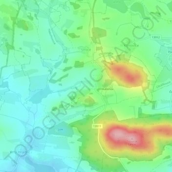
Name: Únice topographic map, elevation, terrain.
Location: Únice, okres Strakonice, Southwest, Czechia (49.28749 13.85507 49.32207 13.89867)
Average elevation: 1,535 ft
Minimum elevation: 1,371 ft
Maximum elevation: 1,926 ft
Make a donation
Gear up for your next adventure:
As an Amazon Associate, this site earns from qualifying purchases at no extra cost to you.
Other topographic maps
Click on a map to view its topography, its elevation and its terrain.
Make a donation
Gear up for your next adventure:
As an Amazon Associate, this site earns from qualifying purchases at no extra cost to you.
Climbing terrain Jickovice
Czechia > Southwest > Jihočeský kraj > Jickovice
Average elevation: 1,358 ft
Rakovické Chalupy
Czechia > Southwest > Jihočeský kraj > Mirotice > Rakovické Chalupy
Average elevation: 1,450 ft