Geolocate

Wetumpka topographic map

Click on the map to display elevation.

About this map

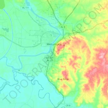
Name: Wetumpka topographic map, elevation, terrain.

Location: Wetumpka, Elmore County, Alabama, United States (32.45497 -86.25892 32.59500 -86.15278)

Average elevation: 253 ft

Minimum elevation: 115 ft

Maximum elevation: 604 ft

Elmore County trails, hiking, mountain biking, running and outdoor activities

Other topographic maps

Click on a map to view its topography, its elevation and its terrain.

Five Points

United States > Alabama > Elmore County > Millbrook

Average elevation: 200 ft

Broadmoor

United States > Alabama > Elmore County > Millbrook

Average elevation: 233 ft

Springfield

United States > Alabama > Elmore County > Millbrook

Average elevation: 312 ft

Jordan

United States > Alabama > Elmore County

Average elevation: 568 ft

Wallsboro

United States > Alabama > Elmore County

Average elevation: 240 ft

Governor's Island

United States > Alabama > Elmore County

Average elevation: 538 ft

Weoka Creek

United States > Alabama > Elmore County

Average elevation: 407 ft

Gear up for your next adventure:

🕶️Glacier Sunglasses - Side shields to protect eyes from high-altitude snow glare
🔦Powerful Headlamps - Ultra-bright hands-free lighting for night navigation
🔥Camping Stove - Portable stove for camping and backcountry cooking
🗃️Trail First Aid Kit - Essential kit for outdoor injuries and emergencies
🪄Magnetic Compass - Accurate compass for navigation

As an Amazon Associate, this site earns from qualifying purchases at no extra cost to you.