Geolocate

Aurora topographic map

Click on the map to display elevation.

About this map

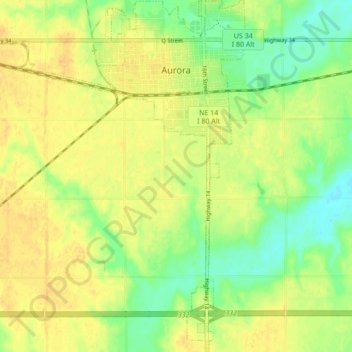
Name: Aurora topographic map, elevation, terrain.

Location: Aurora, Hamilton County, Nebraska, 68818, United States (40.81508 -98.05470 40.87975 -97.98768)

Average elevation: 1,785 ft

Minimum elevation: 1,732 ft

Maximum elevation: 1,821 ft

Hamilton County trails, hiking, mountain biking, running and outdoor activities

Other topographic maps

Click on a map to view its topography, its elevation and its terrain.

Overland

United States > Nebraska > Hamilton County

Average elevation: 1,709 ft

Gear up for your next adventure:

😴Insulated Sleeping Pads - Compact and warm pads for high-elevation camping
📱Solar Portable Charger - Solar power bank for charging devices off‑grid
🛡️Insect Repellent - Protection against bugs during outdoor activities
🎒Day Hiking Backpack - Lightweight backpack perfect for day trips and outdoor adventures
🛰️Satellite Messengers - Emergency SOS and two-way messaging for off-grid adventures

As an Amazon Associate, this site earns from qualifying purchases at no extra cost to you.