
Make a donation
Gear up for your next adventure:
As an Amazon Associate, this site earns from qualifying purchases at no extra cost to you.
Ilha de Santa Maria topographic map
Click on the map to display elevation.
Make a donation
Gear up for your next adventure:
As an Amazon Associate, this site earns from qualifying purchases at no extra cost to you.
Ilha de Santa Maria
On 8 February 1989, an American chartered Boeing 707 of Independent Air Flight 1851 crashed at Pico Alto, killing all 137 passengers and 7 members of the crew. There was confusion between tower and pilots as to the appropriate altitude during their approach.
Make a donation
Gear up for your next adventure:
As an Amazon Associate, this site earns from qualifying purchases at no extra cost to you.
About this map
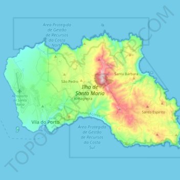
Name: Ilha de Santa Maria topographic map, elevation, terrain.
Average elevation: 266 ft
Minimum elevation: -3 ft
Maximum elevation: 1,867 ft
Make a donation
Gear up for your next adventure:
As an Amazon Associate, this site earns from qualifying purchases at no extra cost to you.