
Make a donation
Gear up for your next adventure:
As an Amazon Associate, this site earns from qualifying purchases at no extra cost to you.
Covas topographic map
Click on the map to display elevation.
Make a donation
Gear up for your next adventure:
As an Amazon Associate, this site earns from qualifying purchases at no extra cost to you.
About this map
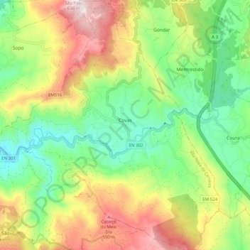
Name: Covas topographic map, elevation, terrain.
Location: Covas, Vila Nova de Cerveira, Viana do Castelo, Portugal (41.84668 -8.74745 41.92097 -8.65653)
Average elevation: 886 ft
Minimum elevation: 85 ft
Maximum elevation: 2,077 ft
Make a donation
Gear up for your next adventure:
As an Amazon Associate, this site earns from qualifying purchases at no extra cost to you.
Other topographic maps
Click on a map to view its topography, its elevation and its terrain.
Vila Nova de Cerveira
Portugal > Viana do Castelo > Vila Nova de Cerveira
O ponto mais alto do município situa-se no alto de São Paio, com 638 metros de altitude, na freguesia de Loivo.
Average elevation: 440 ft
Make a donation
Gear up for your next adventure:
As an Amazon Associate, this site earns from qualifying purchases at no extra cost to you.
Castelo de Vila Nova de Cerveira
Portugal > Viana do Castelo > Vila Nova de Cerveira
Average elevation: 194 ft