Geolocate

Stadtlohn topographic map

Click on the map to display elevation.

About this map

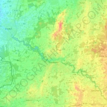
Name: Stadtlohn topographic map, elevation, terrain.

Location: Stadtlohn, Kreis Borken, North Rhine-Westphalia, 48703, Germany (51.96189 6.82843 52.04632 7.05041)

Average elevation: 177 ft

Minimum elevation: 115 ft

Maximum elevation: 259 ft

Other topographic maps

Click on a map to view its topography, its elevation and its terrain.

SO2

Germany > North Rhine-Westphalia > Kreis Borken > Bocholt

Average elevation: 105 ft

Gear up for your next adventure:

🧭Compass with Lanyard - Easy‑carry compass for navigation
🏥Hiking First Aid Kits - Comprehensive medical kits for remote trail injuries
🩳Quick‑Dry Hiking Shorts - Comfortable and quick‑dry shorts for summer hiking
🗺️NatGeo Topo Maps - High-quality waterproof printed topographic maps of US Parks
🛰️Satellite Messengers - Emergency SOS and two-way messaging for off-grid adventures

As an Amazon Associate, this site earns from qualifying purchases at no extra cost to you.