Geolocate

Confidence topographic map

Click on the map to display elevation.

About this map

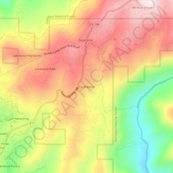
Name: Confidence topographic map, elevation, terrain.

Location: Confidence, Tuolumne County, California, 95346, United States (38.02742 -120.22130 38.06742 -120.18130)

Average elevation: 3,986 ft

Minimum elevation: 2,989 ft

Maximum elevation: 4,770 ft

Tuolumne County trails, hiking, mountain biking, running and outdoor activities

Other topographic maps

Click on a map to view its topography, its elevation and its terrain.

Columbia

United States > California > Tuolumne County

Columbia is located along State Route 49 just north of Sonora, at an altitude of 2,139 feet (652 m).

Average elevation: 2,205 ft

Siesta Lake

United States > California > Tuolumne County

Average elevation: 8,136 ft

East Sonora

United States > California > Tuolumne County

Average elevation: 2,215 ft

Budd Lake

United States > California > Tuolumne County

Average elevation: 10,174 ft

Pinecrest Lake

United States > California > Tuolumne County

Average elevation: 5,902 ft

Mono Vista

United States > California > Tuolumne County

Average elevation: 3,048 ft

Gear up for your next adventure:

🔌USB Car Charger - Car charger for on‑the‑go power needs
😴Insulated Sleeping Pads - Compact and warm pads for high-elevation camping
🗺️NatGeo Topo Maps - High-quality waterproof printed topographic maps of US Parks
GPS Sports Watch - GPS watch for running, hiking and training
🚗GPS Dash Cams - Record your scenic drives through mountain passes and canyons

As an Amazon Associate, this site earns from qualifying purchases at no extra cost to you.