Vita topographic map
Interactive map
Click on the map to display elevation.
About this map
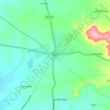
Name: Vita topographic map, elevation, terrain.
Location: Vita, Khanapur, Sangli District, Maharashtra, 415311, India (17.23198 74.49728 17.31198 74.57728)
Average elevation: 2,287 ft
Minimum elevation: 2,126 ft
Maximum elevation: 2,848 ft
Other topographic maps
Click on a map to view its topography, its elevation and its terrain.
Vejegaon
India > Maharashtra > Khanapur
Vejegaon, Khanapur, Sangli, Maharashtra, 415310, India
Average elevation: 2,362 ft
Bhivghat
India > Maharashtra > Khanapur
Bhivghat, Khanapur, Sangli, Maharashtra, India
Average elevation: 2,572 ft