
Haifa topographic map
Click on the map to display elevation.
Haifa
Haifa is the center of liberal Arabic-speaking culture, as it was under British colonial rule. The Arabic-speaking neighborhoods, which are mixed Muslim and Christian, are in the lowlands near the sea, while Jewish neighborhoods are at higher elevation. An active Arab cultural life has developed in the 21st century. The city is center of many Arab-owned businesses such as theaters, bars, cafes, restaurants and nightclubs which host also a different cultural discussions and art exhibitions.
About this map
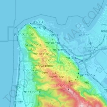
Name: Haifa topographic map, elevation, terrain.
Location: Haifa, Haifa Subdistrict, Haifa District, Israel (32.75795 34.94860 32.84753 35.07974)
Average elevation: 226 ft
Minimum elevation: -13 ft
Maximum elevation: 1,654 ft
Other topographic maps
Click on a map to view its topography, its elevation and its terrain.
Nahal Taninim
Israel > Haifa District > Hof HaCarmel Regional Council > Caesarea
Average elevation: 105 ft
Caesarea National Park
Israel > Haifa District > Hof HaCarmel Regional Council > Caesarea
Average elevation: 26 ft
Haifa
Haifa is the center of liberal Arabic-speaking culture, as it was under British colonial rule. The Arabic-speaking neighborhoods, which are mixed Muslim and Christian, are in the lowlands near the sea, while Jewish neighborhoods are at higher elevation. An active Arab cultural life has developed in the 21st…
Average elevation: 328 ft
Hof Dor & Ma'agan Michael Islans Nature Reserve
Israel > Haifa District > Hof HaCarmel Regional Council
Average elevation: 7 ft
Magal
Israel > Haifa District > Menashe Regional Council
Kibbutz Magal was founded in 1953 as a Nahal settlement on a hill overlooking the Samaria hills and what was then the border with Jordan. The kibbutz sits on a hill known from the War of Independence as the "86th Regiment"—on any elevation of the hill above the sea level (86 meters). The kibbutz was founded…
Average elevation: 213 ft