Geolocate

Foggia topographic map

Click on the map to display elevation.

About this map

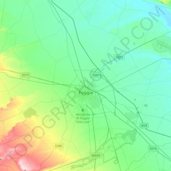
Name: Foggia topographic map, elevation, terrain.

Location: Foggia, Apulia, Italy (41.33267 15.43032 41.61303 15.78888)

Average elevation: 279 ft

Minimum elevation: 26 ft

Maximum elevation: 1,224 ft

Other topographic maps

Click on a map to view its topography, its elevation and its terrain.

San Domino

Italy > Apulia > Foggia > San Nicola

Average elevation: 16 ft

Padre Pio

Italy > Apulia > Foggia > Cerignola

Average elevation: 371 ft

Gear up for your next adventure:

📡Handheld GPS Device - Reliable handheld GPS for outdoor navigation
🧯Portable Fire Pit - Compact fire pit for camping spots
🗻Climbing Gear Basics - Essential gear for beginner climbers
🎒Day Hiking Backpack - Lightweight backpack perfect for day trips and outdoor adventures
GPS Sports Watch - GPS watch for running, hiking and training

As an Amazon Associate, this site earns from qualifying purchases at no extra cost to you.