
Make a donation
Gear up for your next adventure:
As an Amazon Associate, this site earns from qualifying purchases at no extra cost to you.
Unterrothorn topographic map
Click on the map to display elevation.
Make a donation
Gear up for your next adventure:
As an Amazon Associate, this site earns from qualifying purchases at no extra cost to you.
Unterrothorn
L'Unterrothorn est une montagne du canton du Valais, en Suisse, culminant à 3 102 mètres d'altitude et surplombant la station de Zermatt, à environ 5 km à l’est.
Make a donation
Gear up for your next adventure:
As an Amazon Associate, this site earns from qualifying purchases at no extra cost to you.
About this map
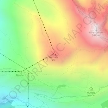
Name: Unterrothorn topographic map, elevation, terrain.
Location: Unterrothorn, Zermatt, Viège, Valais, 3920, Suisse (46.02143 7.79754 46.02153 7.79764)
Average elevation: 8,907 ft
Minimum elevation: 6,939 ft
Maximum elevation: 11,165 ft
Make a donation
Gear up for your next adventure:
As an Amazon Associate, this site earns from qualifying purchases at no extra cost to you.
Other topographic maps
Click on a map to view its topography, its elevation and its terrain.
Glacier du Gorner
Suisse > Valais > Viège > Zermatt
Le glacier du Gorner (Gornergletscher en allemand) se trouve en Suisse dans le canton du Valais. Situé sur le massif du mont Rose au sud-est de Zermatt, le glacier du Gorner, avec ses 14 kilomètres, est le troisième plus long de Suisse après le glacier d'Aletsch et le glacier de Fiesch. Sa largeur atteint…
Average elevation: 10,430 ft