
Make a donation
Gear up for your next adventure:
As an Amazon Associate, this site earns from qualifying purchases at no extra cost to you.
Qüxü County topographic map
Click on the map to display elevation.
Make a donation
Gear up for your next adventure:
As an Amazon Associate, this site earns from qualifying purchases at no extra cost to you.
Qüxü County
In the Tibetan language, the name means "water ditch." Qüxü County has a total area of 1,680 square kilometres (650 sq mi), with an average elevation of 3,650 metres (11,980 ft). The county is in the Yarlung Tsangpo valley, and is mostly relatively flat, but rises to the Nyainqêntanglha Mountains in the north. The Lhasa River runs south through the eastern part of the county to its confluence with the Yarlung Tsangpo River, which forms the southern boundary of the county. The lowest elevation is 3,500 meters, and the highest summit elevation is 5894 meters.
Make a donation
Gear up for your next adventure:
As an Amazon Associate, this site earns from qualifying purchases at no extra cost to you.
About this map
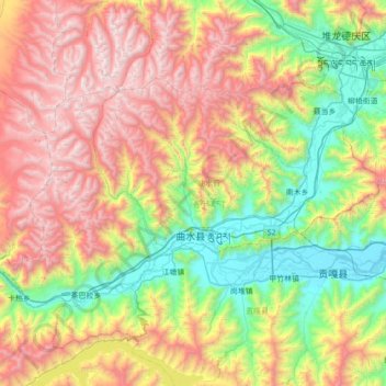
Name: Qüxü County topographic map, elevation, terrain.
Location: Qüxü County, Lhasa, Tibet, China (29.24065 90.36293 29.60142 91.06113)
Average elevation: 14,810 ft
Minimum elevation: 11,680 ft
Maximum elevation: 19,406 ft
Make a donation
Gear up for your next adventure:
As an Amazon Associate, this site earns from qualifying purchases at no extra cost to you.
Other topographic maps
Click on a map to view its topography, its elevation and its terrain.
Yangbajain
The Yangbajain hot springs field is at an elevation of 4,290 to 4,500 metres (14,070 to 14,760 ft) which makes it the highest elevation set of hot springs in China, and possibly the world. The highest temperature inside the drilling hole is 125.5°C.
Average elevation: 14,593 ft