Geolocate

Indian Springs topographic map

Click on the map to display elevation.

About this map

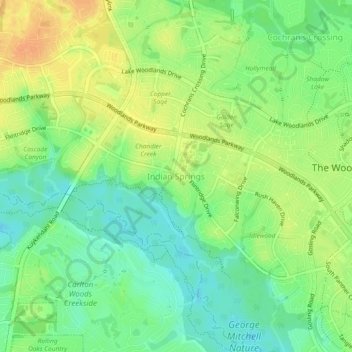
Name: Indian Springs topographic map, elevation, terrain.

Location: Indian Springs, The Woodlands, Montgomery County, Texas, 77381, United States (30.15242 -95.54726 30.19242 -95.50726)

Average elevation: 157 ft

Minimum elevation: 105 ft

Maximum elevation: 217 ft

Other topographic maps

Click on a map to view its topography, its elevation and its terrain.

Gear up for your next adventure:

📦Gear Storage Bags - Organize and protect outdoor equipment
🕶️GPS Smartphone Mount - Secure mount for phone navigation
🧣Hiking Neck Gaiter - Multi‑use neck protection for outdoor weather
🎒Trail Energy Bars - High‑calorie bars for hiking energy
🛏️Cold Weather Sleeping Bag - Warm sleeping bag for cold conditions

As an Amazon Associate, this site earns from qualifying purchases at no extra cost to you.