Geolocate

High Springs topographic map

Click on the map to display elevation.

About this map

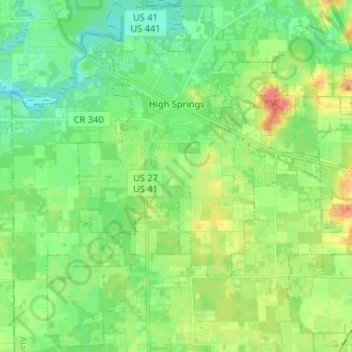
Name: High Springs topographic map, elevation, terrain.

Location: High Springs, Alachua County, Florida, 32655, United States (29.74830 -82.64500 29.85839 -82.51422)

Average elevation: 82 ft

Minimum elevation: 26 ft

Maximum elevation: 180 ft

Alachua County trails, hiking, mountain biking, running and outdoor activities

Other topographic maps

Click on a map to view its topography, its elevation and its terrain.

Lakeview Estates

United States > Florida > Alachua County

Average elevation: 115 ft

Island Grove

United States > Florida > Alachua County

Average elevation: 59 ft

Earleton

United States > Florida > Alachua County

Average elevation: 151 ft

Bland

United States > Florida > Alachua County

Average elevation: 144 ft

Archer

United States > Florida > Alachua County > Archer

Average elevation: 82 ft

Gear up for your next adventure:

🧯Portable Fire Pit - Compact fire pit for camping spots
🛠️Backpacking Tool Kit - Essential toolkit for outdoor repairs
🛌Ultralight Sleeping Bags - Compact down bags for cold nights in the wilderness
🕶️GPS Smartphone Mount - Secure mount for phone navigation
Solar GPS Watches - Advanced multisport watches with built-in topographic maps

As an Amazon Associate, this site earns from qualifying purchases at no extra cost to you.