
Thank you for supporting this site ❤️
Make a donation
Make a donation
Gear up for your next adventure:
As an Amazon Associate, this site earns from qualifying purchases at no extra cost to you.
Lucrepata topographic map
Click on the map to display elevation.
Thank you for supporting this site ❤️
Make a donation
Make a donation
Gear up for your next adventure:
As an Amazon Associate, this site earns from qualifying purchases at no extra cost to you.
About this map
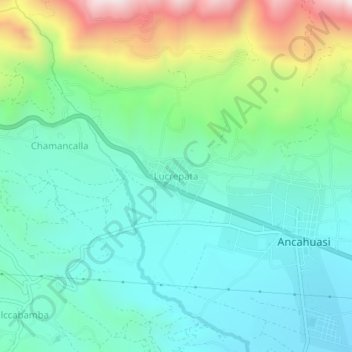
Name: Lucrepata topographic map, elevation, terrain.
Location: Lucrepata, Ancahuasi, Provincia de Anta, Cuzco, Perú (-13.46962 -72.33555 -13.42962 -72.29555)
Average elevation: 11,909 ft
Minimum elevation: 11,188 ft
Maximum elevation: 13,894 ft
Thank you for supporting this site ❤️
Make a donation
Make a donation
Gear up for your next adventure:
As an Amazon Associate, this site earns from qualifying purchases at no extra cost to you.