
Make a donation
Gear up for your next adventure:
As an Amazon Associate, this site earns from qualifying purchases at no extra cost to you.
Imgenbroich topographic map
Click on the map to display elevation.
Make a donation
Gear up for your next adventure:
As an Amazon Associate, this site earns from qualifying purchases at no extra cost to you.
Imgenbroich
Imgenbroich ['ɪm.ʃɛn.bʀʊx] ist ein Stadtteil von Monschau in der Städteregion Aachen und liegt direkt oberhalb Monschaus auf den Eifelhöhen.
Make a donation
Gear up for your next adventure:
As an Amazon Associate, this site earns from qualifying purchases at no extra cost to you.
About this map
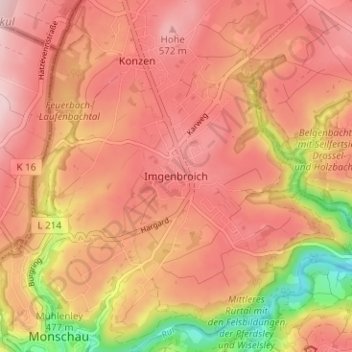
Name: Imgenbroich topographic map, elevation, terrain.
Average elevation: 1,686 ft
Minimum elevation: 1,198 ft
Maximum elevation: 1,929 ft
Make a donation
Gear up for your next adventure:
As an Amazon Associate, this site earns from qualifying purchases at no extra cost to you.
Other topographic maps
Click on a map to view its topography, its elevation and its terrain.
Troisdorfer Weiher
Deutschland > Nordrhein-Westfalen > Städteregion Aachen > Monschau > Konzen
Average elevation: 1,791 ft
Kalltal
Deutschland > Nordrhein-Westfalen > Städteregion Aachen > Monschau > Entenpfuhl
Average elevation: 1,811 ft