Geolocate

Mandrem topographic map

Click on the map to display elevation.

About this map

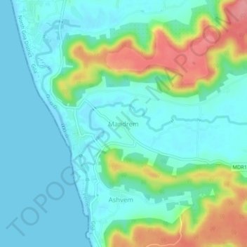
Name: Mandrem topographic map, elevation, terrain.

Location: Mandrem, Pernem, North Goa, Goa, 403527, India (15.63511 73.69979 15.67511 73.73979)

Average elevation: 62 ft

Minimum elevation: -3 ft

Maximum elevation: 292 ft

Other topographic maps

Click on a map to view its topography, its elevation and its terrain.

Morjim Beach

India > Goa > Pernem

Average elevation: 10 ft

Arambol Sweet Water Lake

India > Goa > Pernem > Arambol

Average elevation: 82 ft

Gear up for your next adventure:

🧭Pro Hiking Compasses - High-accuracy liquid-filled compasses for topographic orientation
🩹Survival Bandages - High‑quality bandages for emergencies
Camping Coffee Makers - Enjoy premium coffee at the summit or campsite
📶Vehicle Signal Boosters - Improve reception in rural areas while driving to trailheads
🔪Outdoor Multitools - Essential survival tools for gear repair and field use

As an Amazon Associate, this site earns from qualifying purchases at no extra cost to you.