Geolocate

Mount Bailey topographic map

Click on the map to display elevation.

About this map

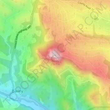
Name: Mount Bailey topographic map, elevation, terrain.

Location: Mount Bailey, Bailey, Park County, Colorado, United States (39.41522 -105.45977 39.41532 -105.45967)

Average elevation: 8,310 ft

Minimum elevation: 7,707 ft

Maximum elevation: 9,016 ft

Park County trails, hiking, mountain biking, running and outdoor activities

Gear up for your next adventure:

🪶Multi‑Purpose Knife - Useful blade for camp and trail
🔭Stargazing Telescopes - Perfect for camping in low-light pollution areas shown on maps
Backpacking Tents - Weight-optimized shelters for multi-day topographic surveys
🌡️Portable Weather Meter - Track weather conditions on the trail
🧺Microfiber Travel Towels - Compact and fast-drying towels for trail use

As an Amazon Associate, this site earns from qualifying purchases at no extra cost to you.