Geolocate

76227 topographic map

Click on the map to display elevation.

About this map

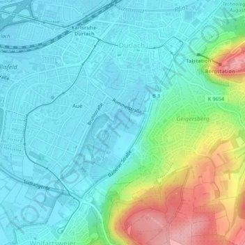
Name: 76227 topographic map, elevation, terrain.

Location: 76227, Durlach, Karlsruhe, Baden-Württemberg, Germany (48.95801 8.42885 49.02393 8.51045)

Average elevation: 531 ft

Minimum elevation: 351 ft

Maximum elevation: 1,047 ft

Other topographic maps

Click on a map to view its topography, its elevation and its terrain.

Untere Hub

Germany > Baden-Württemberg > Karlsruhe

Average elevation: 397 ft

Erlachsee

Germany > Baden-Württemberg > Karlsruhe > Durlach

Average elevation: 384 ft

Gear up for your next adventure:

🧭Map Reading Tools - Tools and kits for map navigation
🔋Solar Power Banks - Keep your GPS and phone charged in remote wilderness areas
🧭Outdoor Navigation Book - Learn advanced navigation skills
🎒Hydration Pack - Hands‑free water reservoir for long hikes
🚪Portable Camp Chair - Foldable chair for comfort at camp

As an Amazon Associate, this site earns from qualifying purchases at no extra cost to you.