
Thank you for supporting this site ❤️
Make a donation
Make a donation
Gear up for your next adventure:
As an Amazon Associate, this site earns from qualifying purchases at no extra cost to you.
Muquiyauyo topographic map
Click on the map to display elevation.
Thank you for supporting this site ❤️
Make a donation
Make a donation
Gear up for your next adventure:
As an Amazon Associate, this site earns from qualifying purchases at no extra cost to you.
About this map
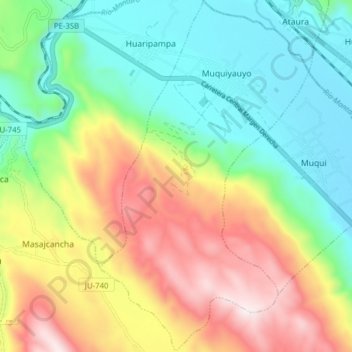
Name: Muquiyauyo topographic map, elevation, terrain.
Location: Muquiyauyo, Provincia de Jauja, Junín, Perú (-11.87431 -75.48193 -11.79810 -75.43569)
Average elevation: 11,745 ft
Minimum elevation: 10,830 ft
Maximum elevation: 13,481 ft
Thank you for supporting this site ❤️
Make a donation
Make a donation
Gear up for your next adventure:
As an Amazon Associate, this site earns from qualifying purchases at no extra cost to you.