
Make a donation
Gear up for your next adventure:
As an Amazon Associate, this site earns from qualifying purchases at no extra cost to you.
Azé topographic map
Click on the map to display elevation.
Make a donation
Gear up for your next adventure:
As an Amazon Associate, this site earns from qualifying purchases at no extra cost to you.
About this map
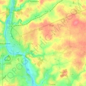
Name: Azé topographic map, elevation, terrain.
Average elevation: 207 ft
Minimum elevation: 72 ft
Maximum elevation: 331 ft
Make a donation
Gear up for your next adventure:
As an Amazon Associate, this site earns from qualifying purchases at no extra cost to you.
Other topographic maps
Click on a map to view its topography, its elevation and its terrain.
Plan d'eau de la Roche
France > Pays de la Loire > Mayenne > Château-Gontier-sur-Mayenne
Average elevation: 177 ft
Le Cheval Blanc
France > Pays de la Loire > Mayenne > Château-Gontier-sur-Mayenne > Château-Gontier
Average elevation: 194 ft
Jardin du Bout du Monde
France > Pays de la Loire > Mayenne > Château-Gontier-sur-Mayenne > Château-Gontier
Average elevation: 167 ft
La Bruyère
France > Pays de la Loire > Mayenne > Château-Gontier-sur-Mayenne
Average elevation: 200 ft
Make a donation
Gear up for your next adventure:
As an Amazon Associate, this site earns from qualifying purchases at no extra cost to you.