
Make a donation
Gear up for your next adventure:
As an Amazon Associate, this site earns from qualifying purchases at no extra cost to you.
Laguna Piuray topographic map
Click on the map to display elevation.
Make a donation
Gear up for your next adventure:
As an Amazon Associate, this site earns from qualifying purchases at no extra cost to you.
Laguna Piuray
La laguna Piuray es una fuente de agua o laguna de origen superficial ubicada en la Cordillera Vilcanota en la región Cusco en Perú, tiene un color azul oscuro que refleja el inmenso cielo andino. Está situada a 31 kilómetros de la ciudad de Cusco, a una altitud de 3 435 m s. n. m.
Make a donation
Gear up for your next adventure:
As an Amazon Associate, this site earns from qualifying purchases at no extra cost to you.
About this map
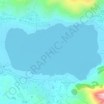
Name: Laguna Piuray topographic map, elevation, terrain.
Average elevation: 12,221 ft
Minimum elevation: 12,096 ft
Maximum elevation: 13,123 ft
Make a donation
Gear up for your next adventure:
As an Amazon Associate, this site earns from qualifying purchases at no extra cost to you.