
Thank you for supporting this site ❤️
Make a donation
Make a donation
Gear up for your next adventure:
As an Amazon Associate, this site earns from qualifying purchases at no extra cost to you.
Orvalho topographic map
Click on the map to display elevation.
Thank you for supporting this site ❤️
Make a donation
Make a donation
Gear up for your next adventure:
As an Amazon Associate, this site earns from qualifying purchases at no extra cost to you.
About this map
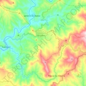
Name: Orvalho topographic map, elevation, terrain.
Location: Orvalho, Oleiros, Castelo Branco, Portugal (39.99060 -7.82831 40.03574 -7.69109)
Average elevation: 1,745 ft
Minimum elevation: 961 ft
Maximum elevation: 3,002 ft
Thank you for supporting this site ❤️
Make a donation
Make a donation
Gear up for your next adventure:
As an Amazon Associate, this site earns from qualifying purchases at no extra cost to you.