Geolocate

Hogeye topographic map

Click on the map to display elevation.

About this map

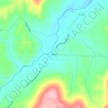
Name: Hogeye topographic map, elevation, terrain.

Location: Hogeye, Washington County, Arkansas, United States (35.90036 -94.28771 35.94036 -94.24771)

Average elevation: 1,358 ft

Minimum elevation: 1,188 ft

Maximum elevation: 1,775 ft

Washington County trails, hiking, mountain biking, running and outdoor activities

Other topographic maps

Click on a map to view its topography, its elevation and its terrain.

Elm Springs

United States > Arkansas > Washington County

Average elevation: 1,247 ft

Winslow

United States > Arkansas > Washington County > Winslow

Average elevation: 1,844 ft

Lincoln

United States > Arkansas > Washington County

Average elevation: 1,430 ft

Johnson

United States > Arkansas > Washington County

Average elevation: 1,260 ft

Goshen

United States > Arkansas > Washington County

Average elevation: 1,299 ft

Gear up for your next adventure:

📌Outdoor GPS Map App - Apps and devices for digital topographic navigation
🚑Emergency Bivvies - Heat-reflective sleeping bags for survival situations
🛶Inflatable Kayak - Portable kayak for rivers, lakes, and expeditions
🧤Tactile Hiking Gloves - Keep hands warm while operating GPS and smartphone screens
🌧️Backpack Rain Cover - Keep gear dry in wet weather

As an Amazon Associate, this site earns from qualifying purchases at no extra cost to you.