
Thank you for supporting this site ❤️
Make a donation
Make a donation
Gear up for your next adventure:
As an Amazon Associate, this site earns from qualifying purchases at no extra cost to you.
Rodalquilar topographic map
Click on the map to display elevation.
Thank you for supporting this site ❤️
Make a donation
Make a donation
Gear up for your next adventure:
As an Amazon Associate, this site earns from qualifying purchases at no extra cost to you.
About this map
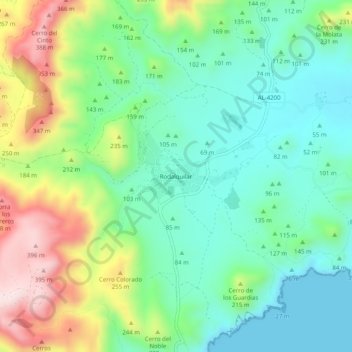
Name: Rodalquilar topographic map, elevation, terrain.
Location: Rodalquilar, Níjar, Almería, Andalucía, 04115, España (36.82680 -2.06060 36.86680 -2.02060)
Average elevation: 436 ft
Minimum elevation: 0 ft
Maximum elevation: 1,339 ft
Thank you for supporting this site ❤️
Make a donation
Make a donation
Gear up for your next adventure:
As an Amazon Associate, this site earns from qualifying purchases at no extra cost to you.