Geolocate

Bonita topographic map

Click on the map to display elevation.

About this map

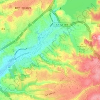
Name: Bonita topographic map, elevation, terrain.

Location: Bonita, San Diego County, California, 91902, United States (32.63812 -117.06577 32.69168 -116.98976)

Average elevation: 305 ft

Minimum elevation: 43 ft

Maximum elevation: 614 ft

San Diego County trails, hiking, mountain biking, running and outdoor activities

Gear up for your next adventure:

🧭Compass with Lanyard - Easy‑carry compass for navigation
🔋Solar Power Banks - Keep your GPS and phone charged in remote wilderness areas
📻Weather Alert Radios - Stay informed of storm risks while off-the-grid
🪶Fire Starter Kit - Reliable fire starter for survival and camping
🔋Rechargeable Batteries - Power up your outdoor devices

As an Amazon Associate, this site earns from qualifying purchases at no extra cost to you.