Geolocate

Tyro topographic map

Click on the map to display elevation.

About this map

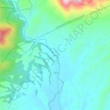
Name: Tyro topographic map, elevation, terrain.

Location: Tyro, Nelson County, Virginia, 22976, United States (37.80153 -79.02475 37.84153 -78.98475)

Average elevation: 1,056 ft

Minimum elevation: 745 ft

Maximum elevation: 2,320 ft

Nelson County trails, hiking, mountain biking, running and outdoor activities

Other topographic maps

Click on a map to view its topography, its elevation and its terrain.

Tye River

United States > Virginia > Nelson County

Average elevation: 823 ft

Piney River

United States > Virginia > Nelson County

Average elevation: 873 ft

Gear up for your next adventure:

🎒Outdoor Daypacks - Lightweight backpacks designed for carrying maps and essential gear
🥾Women's Hiking Boots - Top-rated trail boots with ankle support and superior grip
🧼Biodegradable Camping Soap - Eco‑friendly soap for outdoor hygiene
🔥Plasma Lighters - Windproof lighters that work in any weather condition
🏔️Mountain Trail Maps - High‑detail maps for popular peaks

As an Amazon Associate, this site earns from qualifying purchases at no extra cost to you.