Geolocate

Piedmont topographic map

Click on the map to display elevation.

About this map

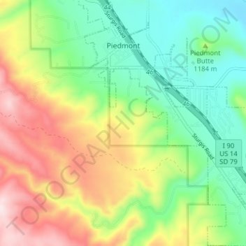
Name: Piedmont topographic map, elevation, terrain.

Location: Piedmont, Meade County, South Dakota, United States (44.19103 -103.40296 44.24629 -103.34762)

Average elevation: 3,868 ft

Minimum elevation: 3,327 ft

Maximum elevation: 4,731 ft

Meade County trails, hiking, mountain biking, running and outdoor activities

Other topographic maps

Click on a map to view its topography, its elevation and its terrain.

Bear Butte

United States > South Dakota > Meade County

Average elevation: 3,314 ft

Gear up for your next adventure:

📶Satellite Messenger - Communication device off‑grid
🗃️Trail First Aid Kit - Essential kit for outdoor injuries and emergencies
🌐World Map Poster - Decorative world maps with topographic info
🥘Titanium Cookware - Durable, featherlight pots and pans for backpacking
🧢Outdoor Hiking Hat - Sun protection hat for outdoor explorers

As an Amazon Associate, this site earns from qualifying purchases at no extra cost to you.