
Oakland topographic map
Click on the map to display elevation.
About this map
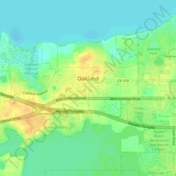
Name: Oakland topographic map, elevation, terrain.
Location: Oakland, Orange County, Florida, 34760, United States (28.54157 -81.65733 28.56472 -81.61626)
Average elevation: 92 ft
Minimum elevation: 49 ft
Maximum elevation: 157 ft
Orange County trails, hiking, mountain biking, running and outdoor activities
Other topographic maps
Click on a map to view its topography, its elevation and its terrain.
Harlem Heights
United States > Florida > Orange County > Winter Garden > Harlem Heights
Average elevation: 118 ft