
Thank you for supporting this site ❤️
Make a donation
Make a donation
Gear up for your next adventure:
As an Amazon Associate, this site earns from qualifying purchases at no extra cost to you.
Borigumma topographic map
Click on the map to display elevation.
Thank you for supporting this site ❤️
Make a donation
Make a donation
Gear up for your next adventure:
As an Amazon Associate, this site earns from qualifying purchases at no extra cost to you.
About this map
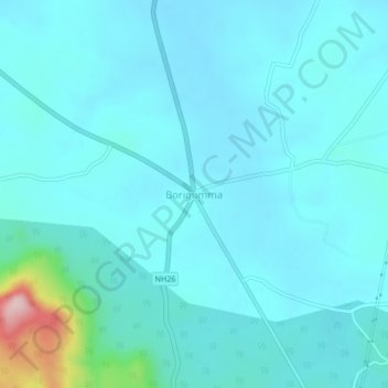
Name: Borigumma topographic map, elevation, terrain.
Location: Borigumma, Boriguma, Koraput District, Odisha, 764056, India (19.02845 82.53359 19.06845 82.57359)
Average elevation: 1,985 ft
Minimum elevation: 1,886 ft
Maximum elevation: 2,743 ft
Thank you for supporting this site ❤️
Make a donation
Make a donation
Gear up for your next adventure:
As an Amazon Associate, this site earns from qualifying purchases at no extra cost to you.