
Make a donation
Gear up for your next adventure:
As an Amazon Associate, this site earns from qualifying purchases at no extra cost to you.
Herne topographic map
Click on the map to display elevation.
Make a donation
Gear up for your next adventure:
As an Amazon Associate, this site earns from qualifying purchases at no extra cost to you.
Herne
Für das Haushaltsjahr 2014 hat die Stadt Herne im Gesamtergebnisplan ein Haushaltsdefizit in ordentlichen Erträgen und Aufwendungen (einschließlich Finanzerträgen und -aufwendungen) in Höhe von 47,8 Millionen Euro (309 Euro je Einwohner) veranschlagt. Dies entspricht dem zweithöchsten Pro-Kopf-Haushaltsdefizit aller kreisfreien Städte in Nordrhein-Westfalen im Jahr 2014.
Make a donation
Gear up for your next adventure:
As an Amazon Associate, this site earns from qualifying purchases at no extra cost to you.
About this map
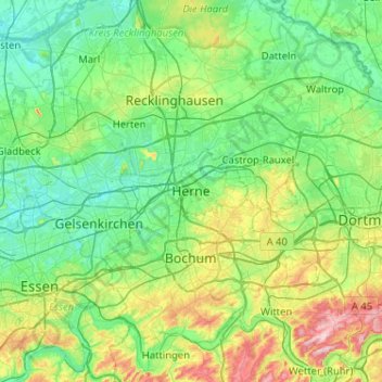
Name: Herne topographic map, elevation, terrain.
Average elevation: 272 ft
Minimum elevation: 85 ft
Maximum elevation: 896 ft
Make a donation
Gear up for your next adventure:
As an Amazon Associate, this site earns from qualifying purchases at no extra cost to you.
Other topographic maps
Click on a map to view its topography, its elevation and its terrain.