Geolocate

Buin topographic map

Click on the map to display elevation.

About this map

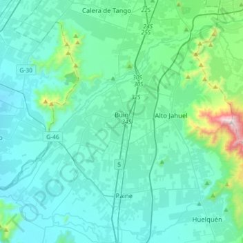
Name: Buin topographic map, elevation, terrain.

Location: Buin, Provincia de Maipo, Santiago Metropolitan Region, Chile (-33.83371 -70.89512 -33.64305 -70.61335)

Average elevation: 1,654 ft

Minimum elevation: 1,093 ft

Maximum elevation: 5,659 ft

Other topographic maps

Click on a map to view its topography, its elevation and its terrain.

Gear up for your next adventure:

🎒Outdoor Daypacks - Lightweight backpacks designed for carrying maps and essential gear
🔥Fast-Boil Camping Stoves - Efficient cooking systems for quick trail meals
🥩Freeze-Dried Meals - Nutritious and lightweight food for remote expeditions
🎒Trail Energy Bars - High‑calorie bars for hiking energy
🪶Camp Gear Gift Set - Perfect gift bundle for outdoor fans

As an Amazon Associate, this site earns from qualifying purchases at no extra cost to you.