Geolocate

Mancini topographic map

Click on the map to display elevation.

About this map

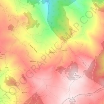
Name: Mancini topographic map, elevation, terrain.

Location: Mancini, Riccia, Campobasso, Molise, Italy (41.44560 14.86497 41.48560 14.90497)

Average elevation: 2,654 ft

Minimum elevation: 1,572 ft

Maximum elevation: 3,245 ft

Gear up for your next adventure:

🚁Photography Drones - Capture stunning aerial views of landforms and topography
🎒Gear Packing Cubes - Organize your backpack efficiently
🕶️GPS Smartphone Mount - Secure mount for phone navigation
🥇GPS Hiking Watch - Multi‑sport GPS watch with navigation and trail tracking
🔥Camping Stove - Portable stove for camping and backcountry cooking

As an Amazon Associate, this site earns from qualifying purchases at no extra cost to you.