
Thank you for supporting this site ❤️
Make a donation
Make a donation
Gear up for your next adventure:
As an Amazon Associate, this site earns from qualifying purchases at no extra cost to you.
Maintal topographic map
Click on the map to display elevation.
Thank you for supporting this site ❤️
Make a donation
Make a donation
Gear up for your next adventure:
As an Amazon Associate, this site earns from qualifying purchases at no extra cost to you.
About this map
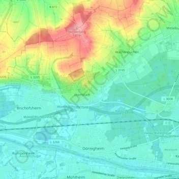
Name: Maintal topographic map, elevation, terrain.
Location: Maintal, Main-Kinzig-Kreis, Hesse, 63477, Germany (50.12498 8.77977 50.18508 8.88235)
Average elevation: 410 ft
Minimum elevation: 305 ft
Maximum elevation: 689 ft
Thank you for supporting this site ❤️
Make a donation
Make a donation
Gear up for your next adventure:
As an Amazon Associate, this site earns from qualifying purchases at no extra cost to you.