Geolocate

Maintal topographic map

Click on the map to display elevation.

About this map

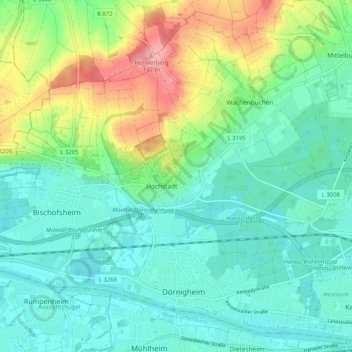
Name: Maintal topographic map, elevation, terrain.

Location: Maintal, Main-Kinzig-Kreis, Hesse, 63477, Germany (50.12498 8.77977 50.18508 8.88235)

Average elevation: 410 ft

Minimum elevation: 305 ft

Maximum elevation: 689 ft

Gear up for your next adventure:

🧤Hiking Gloves - Protective gloves for rugged trails
🔦Compact Flashlight - Reliable flashlight for emergencies
🛰️Handheld GPS Units - Professional satellite navigators for precise backcountry mapping
📻Weather Alert Radios - Stay informed of storm risks while off-the-grid
🪑Portable Camp Table - Compact table for campsite meals

As an Amazon Associate, this site earns from qualifying purchases at no extra cost to you.