Geolocate

Schongau topographic map

Click on the map to display elevation.

About this map

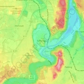
Name: Schongau topographic map, elevation, terrain.

Location: Schongau, Landkreis Weilheim-Schongau, Bavaria, 86956, Germany (47.78384 10.85577 47.84117 10.93225)

Average elevation: 2,365 ft

Minimum elevation: 2,149 ft

Maximum elevation: 2,671 ft

Other topographic maps

Click on a map to view its topography, its elevation and its terrain.

Gear up for your next adventure:

📱Solar Portable Charger - Solar power bank for charging devices off‑grid
🏫Relief Map Kits - Hands-on tools for teaching landforms and elevation
🧺Microfiber Travel Towels - Compact and fast-drying towels for trail use
🪶Compact Camp Shovel - Folding shovel for campsite tasks
🕶️Glacier Sunglasses - Side shields to protect eyes from high-altitude snow glare

As an Amazon Associate, this site earns from qualifying purchases at no extra cost to you.