
Make a donation
Gear up for your next adventure:
As an Amazon Associate, this site earns from qualifying purchases at no extra cost to you.
Schenefeld topographic map
Click on the map to display elevation.
Make a donation
Gear up for your next adventure:
As an Amazon Associate, this site earns from qualifying purchases at no extra cost to you.
Schenefeld
Die Schülerschule wurde 1983 in Schenefeld gegründet, von einer Initiative aus Eltern und Lehrern, die Kinder mit und ohne Behinderung in einer integrativen Schule, individuell nach ihren Begabungen fördern wollten. Die Schule erhielt im August 1985 die Unterrichtsgenehmigung und startete mit einer 1. und einer 5. Klasse in den Räumen der heutigen Volkshochschule Schenefeld an der Blankeneser Chaussee. 1990 zogen die höheren Klassen in Pavillons nach Pinneberg-Waldenau. Seit 1995 ist die Schülerschule staatlich anerkannte Ersatzschule. 2006 zog die Schule komplett nach Pinneberg um.
Make a donation
Gear up for your next adventure:
As an Amazon Associate, this site earns from qualifying purchases at no extra cost to you.
About this map
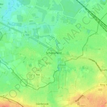
Name: Schenefeld topographic map, elevation, terrain.
Average elevation: 72 ft
Minimum elevation: 20 ft
Maximum elevation: 154 ft
Make a donation
Gear up for your next adventure:
As an Amazon Associate, this site earns from qualifying purchases at no extra cost to you.
Other topographic maps
Click on a map to view its topography, its elevation and its terrain.
Liether Kalkgrube
Deutschland > Schleswig-Holstein > Kreis Pinneberg > Klein Nordende
Average elevation: 46 ft
Tävsmoor/Haselauer Moor
Deutschland > Schleswig-Holstein > Kreis Pinneberg > Appen
Average elevation: 30 ft
Make a donation
Gear up for your next adventure:
As an Amazon Associate, this site earns from qualifying purchases at no extra cost to you.
Stadtpark Lieth
Deutschland > Schleswig-Holstein > Kreis Pinneberg > Elmshorn
Average elevation: 26 ft
Sparrieshoop
Deutschland > Schleswig-Holstein > Kreis Pinneberg > Klein Offenseth-Sparrieshoop
Average elevation: 26 ft