
Make a donation
Gear up for your next adventure:
As an Amazon Associate, this site earns from qualifying purchases at no extra cost to you.
Fort William topographic map
Click on the map to display elevation.
Make a donation
Gear up for your next adventure:
As an Amazon Associate, this site earns from qualifying purchases at no extra cost to you.
Fort William
Fort William has an oceanic climate (Cfb) with moderate, but generally cool, temperatures and abundant precipitation. In the towns immediate vicinity, there are significant variations in elevation, which leads to some uninhabited areas near the town having a subpolar oceanic climate (Cfc), or, at the absolute highest elevations such as Ben Nevis, a tundra climate (ET). Fort William does not have an official MetOffice weather station; as such, the values in the table below are simulated, and the record high and low temperatures are not available.
Make a donation
Gear up for your next adventure:
As an Amazon Associate, this site earns from qualifying purchases at no extra cost to you.
About this map
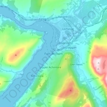
Name: Fort William topographic map, elevation, terrain.
Location: Fort William, Highland, Scotland, PH33 6AQ, United Kingdom (56.77783 -5.15097 56.85783 -5.07097)
Average elevation: 400 ft
Minimum elevation: -7 ft
Maximum elevation: 2,310 ft
Make a donation
Gear up for your next adventure:
As an Amazon Associate, this site earns from qualifying purchases at no extra cost to you.
Other topographic maps
Click on a map to view its topography, its elevation and its terrain.