Geolocate

Turod topographic map

Click on the map to display elevation.

About this map

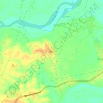
Name: Turod topographic map, elevation, terrain.

Location: Turod, Reina Mercedes, Isabela, Cagayan Valley, Philippines (16.98057 121.76821 17.02057 121.80821)

Average elevation: 154 ft

Minimum elevation: 105 ft

Maximum elevation: 210 ft

Gear up for your next adventure:

🪶Thermal Camp Blanket - Extra warmth for cold nights
🌡️Portable Weather Meter - Track weather conditions on the trail
📱Heavy-Duty Phone Cases - Drop-proof and waterproof protection for outdoor navigation
🛶Inflatable Kayak - Portable kayak for rivers, lakes, and expeditions
🪶LED Camping Lantern - Bright lantern for camp lighting

As an Amazon Associate, this site earns from qualifying purchases at no extra cost to you.