
Thank you for supporting this site ❤️
Make a donation
Make a donation
Gear up for your next adventure:
As an Amazon Associate, this site earns from qualifying purchases at no extra cost to you.
El Paujil topographic map
Click on the map to display elevation.
Thank you for supporting this site ❤️
Make a donation
Make a donation
Gear up for your next adventure:
As an Amazon Associate, this site earns from qualifying purchases at no extra cost to you.
El Paujil
Altitud de la cabecera municipal (metros sobre el nivel del mar): 470 m s. n. m.
Thank you for supporting this site ❤️
Make a donation
Make a donation
Gear up for your next adventure:
As an Amazon Associate, this site earns from qualifying purchases at no extra cost to you.
About this map
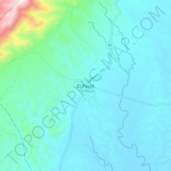
Name: El Paujil topographic map, elevation, terrain.
Location: El Paujil, Caquetá, RAP Amazonía, Colombia (1.53164 -75.36696 1.61164 -75.28696)
Average elevation: 1,365 ft
Minimum elevation: 873 ft
Maximum elevation: 4,652 ft
Thank you for supporting this site ❤️
Make a donation
Make a donation
Gear up for your next adventure:
As an Amazon Associate, this site earns from qualifying purchases at no extra cost to you.