Geolocate

Billawar topographic map

Click on the map to display elevation.

About this map

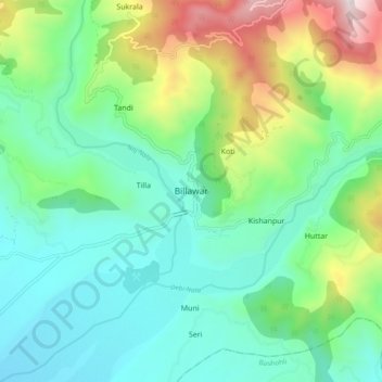
Name: Billawar topographic map, elevation, terrain.

Location: Billawar, Kathua, Jammu and Kashmir, 184204, India (32.57482 75.56330 32.65482 75.64330)

Average elevation: 2,986 ft

Minimum elevation: 1,969 ft

Maximum elevation: 5,705 ft

Gear up for your next adventure:

🧥Men's Rain Shells - Premium waterproof and breathable jackets for mountain weather
🧭Outdoor Navigation Book - Learn advanced navigation skills
📖Nature Tracking Books - Learn to track wildlife and terrain
🚪Portable Camp Chair - Foldable chair for comfort at camp
💧Water Filtration Bottles - Safely drink from streams and lakes while exploring

As an Amazon Associate, this site earns from qualifying purchases at no extra cost to you.