
Thank you for supporting this site ❤️
Make a donation
Make a donation
Gear up for your next adventure:
As an Amazon Associate, this site earns from qualifying purchases at no extra cost to you.
Zhagana topographic map
Click on the map to display elevation.
Thank you for supporting this site ❤️
Make a donation
Make a donation
Gear up for your next adventure:
As an Amazon Associate, this site earns from qualifying purchases at no extra cost to you.
About this map
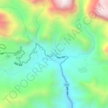
Name: Zhagana topographic map, elevation, terrain.
Location: Zhagana, Yiwa, Têwo County, Gannan, Gansu, 747499, China (34.21843 103.16752 34.25843 103.20752)
Average elevation: 10,673 ft
Minimum elevation: 9,232 ft
Maximum elevation: 13,688 ft
Thank you for supporting this site ❤️
Make a donation
Make a donation
Gear up for your next adventure:
As an Amazon Associate, this site earns from qualifying purchases at no extra cost to you.