
Make a donation
Gear up for your next adventure:
As an Amazon Associate, this site earns from qualifying purchases at no extra cost to you.
Horrheim topographic map
Click on the map to display elevation.
Make a donation
Gear up for your next adventure:
As an Amazon Associate, this site earns from qualifying purchases at no extra cost to you.
Horrheim
Der Baiselsberg nördlich des Ortes ist die höchste Erhebung des Stromberges. Die Weinlagen reichen bis über 350 m Höhe hinauf. In den Lagen darüber ist der Berg mit dichtem Mischwald bedeckt. Auf seiner Südostseite liegt die Klosterruine Baiselsberg. Von den Wegen am Waldrand hat man einen Panoramablick weit über das gesamte Ludwigsburger Unterland bis hin zur Schwäbischen Alb. In den Weinbergwegen ist ein Weinberg-Lehrpfad mit rund hundert verschiedenen Rebsorten eingerichtet.
Make a donation
Gear up for your next adventure:
As an Amazon Associate, this site earns from qualifying purchases at no extra cost to you.
About this map
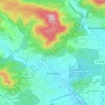
Name: Horrheim topographic map, elevation, terrain.
Average elevation: 909 ft
Minimum elevation: 699 ft
Maximum elevation: 1,558 ft
Make a donation
Gear up for your next adventure:
As an Amazon Associate, this site earns from qualifying purchases at no extra cost to you.