
Make a donation
Gear up for your next adventure:
As an Amazon Associate, this site earns from qualifying purchases at no extra cost to you.
Ingelmunster topographic map
Click on the map to display elevation.
Make a donation
Gear up for your next adventure:
As an Amazon Associate, this site earns from qualifying purchases at no extra cost to you.
Ingelmunster
Ingelmunster ligt in Zandlemig Vlaanderen, ten noorden van de Mandel en het Kanaal Roeselare-Leie. De kerkdrempel ligt op ruim 17 meter hoogte. Het hoogste punt ligt op 38 meter hoogte, ten zuiden van het kanaal.
Make a donation
Gear up for your next adventure:
As an Amazon Associate, this site earns from qualifying purchases at no extra cost to you.
About this map
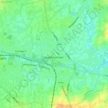
Name: Ingelmunster topographic map, elevation, terrain.
Location: Ingelmunster, Roeselare, West-Vlaanderen, 8770, België (50.89633 3.22987 50.94725 3.29749)
Average elevation: 59 ft
Minimum elevation: 23 ft
Maximum elevation: 128 ft
Make a donation
Gear up for your next adventure:
As an Amazon Associate, this site earns from qualifying purchases at no extra cost to you.
Other topographic maps
Click on a map to view its topography, its elevation and its terrain.
Beitem
België > West-Vlaanderen > Roeselare > Roeselare
Beitem ligt in Zandlemig Vlaanderen op een hoogte van ongeveer 32 meter. De belangrijkste waterloop is de Papelandbeek.
Average elevation: 85 ft