
Red Oak topographic map
Click on the map to display elevation.
About this map
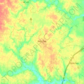
Name: Red Oak topographic map, elevation, terrain.
Location: Red Oak, Nash County, North Carolina, 27868, United States (35.98567 -77.95589 36.08952 -77.85763)
Average elevation: 180 ft
Minimum elevation: 92 ft
Maximum elevation: 269 ft
Nash County trails, hiking, mountain biking, running and outdoor activities
Other topographic maps
Click on a map to view its topography, its elevation and its terrain.
Rocky Mount Millpond Dam
United States > North Carolina > Nash County > Rocky Mount
Average elevation: 105 ft
Brook Valley Trailer Park
United States > North Carolina > Nash County > Rocky Mount > Brook Valley Trailer Park
Average elevation: 157 ft